Getting religious in southern Utah

Boulder

20171230_161937
Birds hanging out in downtown Boulder at sunset

Last December, my brother Will and I took my father, who now has serious trouble walking and resides in an assisted living facility in Austin, Texas, to Utah. The aim was to meet up with some of his longtime friends, mostly members of the Sierra Club, who are infatuated with the Colorado Plateau. These pals and comrades-in-arms have been gathering in a tiny hamlet to ring in the New Year for decades.

20171230_163728
My father checking out bygone prices

Boulder, Utah. Where the heck is that, you might say? Well, you’d be forgiven for your ignorance and yet you would probably want to know more, because it’s a pretty far-out place in many ways. For one thing, it’s in the middle of the southern part of the state of Utah. The big, weird rocks and utter loneliness of the whole area have such an effect on people that I understand my brother when he calls it ‘the church of southern Utah.’ Being there is, in fact, like going to church, in the best sense of the term. You feel reverant and somehow purged of all bad feelings by its mystery, minus the mumbo-jumbo.

20171229_171553
Waterpocket Fold

Now Boulder is supposedly the last town in the lower 48 states to receive mail by mule. The poor mules walked along a scenic trail which some of them apparently fell off from time to time.

20171230_141014
Boulder Mail Trail

Their service to the community ended in the 1930s, when the federal Civilian Conservation Corps finished a gravel road connecting the two metropolises of Boulder, population 266, and Escalante, pop. 878, further to the south. This circuitous link, which goes up and around and down, is called Hell’s Backbone and is kind of a wild ride, too, as the name implies. Most drivers these days would prefer Highway 12 from Escalante or Torrey, to the north. But another possibility is the semi-paved Burr Trail that comes in from the east, and that’s what my brother decided to take to get our father to Boulder for New Year’s Eve.


20171229_164507
Looking eastward from Burr Trail

When I was a teenager in Salt Lake City, I did some backpacking in the canyons of the Escalante (the last river to receive an official name in the lower 48) and its tributaries, including a lovely place called Death Hollow. It may have gotten its name from the long-suffering mules falling into it. It is truly lovely, though. And those trips changed my attitude towards a state I was new to and not getting along with very well. That church of southern Utah experience came over me, and I realized there was something sort of magical down there in those fissures and streambeds and rocks.

I then moved away from the West, and didn’t go back to that part of the state until after Clinton created the Grand Staircase/Escalante National Monument. That seemed like a wondrous thing. Extraordinary land protected forever. Until the end of time. That was the reasoning behind the designation of the first national monument, Devil’s Tower in Wyoming, in 1906. It was supposed to go on like that, forever!


20171230_132417
Grand Staircase/Escalante

But as my father loves to say, after Chaucer, “all good things must come to an end.” I guess that is true, but don’t know it should be so. In any case, the US has had its ups and downs as a country. For example, the bit about the end of time, wasn’t that what the government said to Native Americans over and over? In the 1868 treaty with the Sioux, the Indians were promised the Black Hills of South Dakota forever and ever, until the end of the world. I remember reading that somewhere, maybe in a museum. But the agreement, signed and sealed, only lasted until the next gold rush.

20171230_131636
My brother Will enjoying winter landscape (Grand Staircase/Escalante)


We know, in fact, that the US has not seen the end of the gilded eras of robber barons, blatant and tolerated corruption and total lack of respect for treaties and people’s rights,etc.  Our current president, who doesn’t like exercise and knows nothing about natural beauty, has declared that the monument lands of Grand Staircase/Escalante and Bear’s Ears, created by Obama at the request of five local Native American tribes, have now been reduced by half and 85% respectively. This is to open up these places to oil and coal development and save them from being overprotected for the general public. The general public, ordinary people who like walking, in goobledygook language, have been referred to as ‘special interests.’


20171229_144532
Bear’s Ears from highway 95

Well, when we, my brother, sister-in-law and father, came into southeastern Utah on December 30th (from New Mexico via a tiny piece of Colorado) we drove past the southern end of Bears Ears on state highway 95, a road that doesn’t get much traffic in the winter. We crossed paths with one car on the 90 some miles to the Hite Bridge over the Colorado river. We had a schedule to stick to but I couldn’t help gawking. Bears Ears is sacred to the Navajo, Hopi, Zuni and Ute peoples and is chock full of well-preserved artefacts from ancient dwellings going back over 10,000 years. Not to mention an incredible trove of Triassic fossils.

20171229_145512
Westward-ho along highway 95

But most of that has to go, to allow coal mining or oil drilling to boost the local economy, say local politicians, Secretary of the Interior Zinke and Trump. They think nothing of tearing up places that are akin to Mayan temples or the Vatican. I shook my head. Surely there had to be a way to save all of this fantastic land from fly-by-night activities.

20171229_152246
Looking southward near Hite

We reached the Colorado, crossed the striking white bridge at Hite and then went over the Dirty Devil river soon afterwards. This is the northernmost point of Lake Powell, the reservoir created by the Glen Canyon Dam on the Colorado. The lake is receding and what we saw below us was unnavigable. We stopped to take pictures and I let my old dad out of the car to stretch his numb legs

20171229_2238302-e1520180209796.jpg
Standing tall at Hite Viewpoint

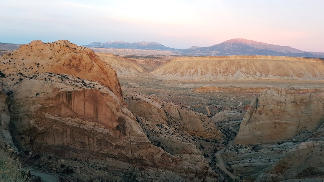
Then we piled back in to continue our drive over to highway 276, which we turned off of just before Lake Powell’s Bullfrog Marina to get onto the Burr Trail. I had never traveled on this particular route before and was wondering why that was so. How could I have missed it? But here we were, at last, on a perfect day in the dead of winter. It’s 67 miles to Boulder and the only sign of humans or development that we encountered, apart from what we were rumbling on, were two gung-ho cyclists and some cows grazing in the southern end of Capitol Reef National Park. No towns, no farms, no houses, no telephone poles, electrical lines, no nothing except for mountains, plateaus, escarpments and canyons. All of that overwhelms you, and also makes you feel thirsty for water, even when it’s cold. No country for unprepared people, that’s for sure.


20171229_161920
Who wants highways? Shortcut to Boulder on Burr Trail

The Henry Mountains (last peaks to be named in the lower 48) appeared off to the east, and the Waterpocket Fold to the west. Capitol Reef was due north.

20171229_223626
My brother and sister-in-law Mia feeling reverent along Burr Trail

At a certain point, we went up over the Fold, which looked as if some gods were messing around and started hurtling slabs of rock into a line of clay. The pieces then got stuck every whichway. That seemed about as plausible an explanation as anything else. What the heck. We all did a lot of gaping and picture snapping and sighing. If we’d lingered a little bit longer, with some alcohol, we might have started speaking in tongues or something.


20171229_225448
Henry Mountains from top of Waterpocket Fold

Our party reached Boulder just after sundown and joined my parents’ old friends at one of their homes. I found a calendar there with pictures of reunions from bygone years, including one with my mother in it. I touched her face. She was gone, but her spirit was here with these people. She had fought the good fight for air quality and preservation of public lands. She also liked Boulder. I remember when she was thinking of selling her house in Salt Lake and buying property here, where the nearest supermarket is over 30 miles away and state liquor store many miles more. “That’s crazy,” I told her. “You like malls, boutiques, theaters….and wine, for god’s sake!” My mother reconsidered, and she and my father, still on more or less amicable terms after their divorce, contented themselves with visiting their community of friends on a yearly basis.

20171230_130036
Easy hiking in Grand Staircase/Escalante

Our hostess this evening thanked me for bringing my father. “Like old times,” she said. Her husband, Gibbs Smith, had passed away very suddenly a few months beforehand and the get-together in 2017 was a tribute to this man, a publisher and man of ideas, who had sort of started the whole Boulder adventure to begin with. After the northern part of highway 12 was finally paved in 1985, the village became easier to get to from the capital. The good road basically put it on the map for nature-loving city slickers.
Gibbs printed some beautiful volumes about the Escalante area itself, one of which I look at fondly now and then. Some of the people I met at our New Year’s Eve gathering, where we quaffed wine that had been brought from all over, included the developer who designed and built the attractive Boulder Mountain Lodge, where we stayed, and a photographer and alpinist who lives near Boulder but travels the world. He said that after going to Ladakh in the winter, he most looks forward to exploring the unknown, unnamed canyons of southeastern Utah in the spring.


20171230_151525
View from terrace of Boulder Mountain Lodge

We briefly discussed the fate of Grand Staircase/Escalante and Bears’ Ears. I was struck by the fact that these seasoned activists didn’t seem to be terribly worried about sudden rampant destruction. They pointed out that many things, such as coal mining on the nearly impenetrable Kaiparowits Plateau, to the west of where we were, had been tried in the ‘70s, and come to nothing. Mining and energy companies want things to be cost effective. Hauling ore that might not be as desirable as in the past from places that have few roads and no people makes even less sense than before. An encouraging sign was that a power plant, the Navajo Generating Station, just south of the Glen Canyon Dam, was slated to be closed. It is the sole customer of a local coal mine. So much for more of that.


20171230_115535
Grand Staircase/Escalante

Utah, as we all know, is a red state, which means that ‘development’ is considered synonymous with ripping up the earth. It is unfortunate that one of the most interesting and intact landscapes on our planet is under the stewardship of people who couldn’t care less about it. But that’s how the cookie crumbles, sometimes, and why you have to be constantly on your toes if you disagree with lax stewards.


20171230_120136

20171230_120225
American History in a cave

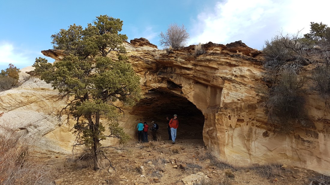
We spent the next few days with our friends who knew every little cave and slot canyon in the neighborhood. I cajoled my father into trying to do part of an easy trail strewn with pieces of petrified rock. I held his hand to get him over slightly steep spots, and waited for him to creep along the flat ones. I knew it might be the last time he had the opportunity to actually hike in the church of southern Utah.


20171231_233329
Old pilgrim

…..
Recommended reading:

Wallace Stegner’s Beyond the Hundredth Meridian, about John Wesley Powell and his explorations and legacy, is a must. Powell, by the way, was the man who named Glen Canyon, the Escalante river (after Father Escalante, the 18th century Spanish explorer), the Dirty Devil river, the Henry Mountains, etc. After getting through the first half of the book, which describes Powell’s trips down the Green and Colorado, you’ll want to throw on a pack and run out into the wilderness yourself.

Trail Guide to Grand Staircase-Escalante National Monument by David Urmann, publisher Gibbs Smith

Desert Solitaire by Edward Abbey

The Monkeywrench Gang by Edward Abbey

Red by Terry Tempest Williams

Archeological significance of Bears’ Ears:
https://www.nature.com/articles/d41586-017-07794-5

Information about Boulder: http://boulder.utah.gov/;

Boulder Mountain Lodge: https://utah.com/boulder-mountain-lodge

Burr Trail: https://www.nps.gov/glca/planyourvisit/driving-the-burr-trail.htm


I Love Rambling

Montello – my favorite little cycling hill

What better thing to do on a clear fall day in northeastern Italy than hop on a road bike and head for the nearest hill? Leave the tedious flood plain surrounding my city of Treviso and go for the closest personal and geolographical relief?

In my case, it’s an elongated mound attached to the northern horizon like a limpet. This greenish limpet is called the Montello, which means “little hill”. “Little” is an understatement, considering the pretty big hills rising up behind it. When the air is free from pesky particulates, you can see the Dolomites standing tall beyond yet another range of foothills.  I always look for those mountains in the paintings of Venetian masters. They were paid to bring Christ and the Madonna and an incredible multitude of saints to life, but couldn’t help adding those fantastical mirage-like backdrops to their work.

20171110_160836
The Montello, preceded by vineyards, topped by a WWI ossuary and half-ruined abbey, and set off by the foothills of the Dolomites.

Pinarello

I pass the flagship store of the Pinarello bicycle makers on my way out of town. I have one of their creations and used to feel proud I was helping the local economy. Now it turns out world-famous Pinarello has been sold to a private equity firm.  But I will always feel loyal to the brand because I’ve had so much fun tooling around on my low-end racing model.

I also liked the old man, the founder and ex-racer Giovanni Pinarello, who would hang out in his store and share his thoughts with customers in a strong local accent, using bicycle jargon when possible. He once poked my brother in the stomach with his cane and told him that he needed to put on the brakes when he got home. My brother used to be as thin as a rail but had expanded in his midriff after moving to Texas, and didn’t take kindly to this kind of comment about his eating habits. Mr. Pinarello was a trim octogenerian himself and a bit of a ladies’ man. When I bought my bike eight years ago, he told me that I’d have men coming after me. My exceptional new speed, of course, would allow me to stay ahead of any male who wanted to compete. Another time he told my husband that I had a good ‘frame’, as if I were a window or a loom, although I was swathed at that moment in a shapeless floor-length winter coat. Yet I didn’t mind being compared to a pair of glasses. I was just happy that anyone was taking my desire to ride a decent bike seriously.

Well, it was a strain for me to understand Mr Pinarello’s lingo. I’ve lived in Veneto for over ten years but have been lazy about picking up the accent or dialect. I thought standard Italian would be enough but I am sometimes stumped when dealing with older people and the populace in general after they’ve had a few glasses of wine. And now that a referendum on some sort of autonomy for this region won by a landslide a few weeks ago, maybe the time has come to take an accelerated course in Trevigiano. The best place to start would be a bar.

Venetian Timber Reserve

But let’s go back to my great day riding to my little hill, which was one of the Venetian Republic’s timber reserves for at least three centuries. The Serenissima guarded their trees with vigor. Although that fine example of forestry vanished when the Republic disintegrated after Napoleon’s arrival in the late 18th century, the Montello still has something special about it.

20171110_163044
Presa 16 from the south

Getting to the Montello from Treviso

I take the Via Montello, which starts right outside the ringroad circling the historic center of Treviso. There can be a lot of traffic on this route for the first ten kilometres, depending on the time of day. Some stretches have cycling lanes which then end abruptly. I mostly stay on the road and make sure cars have to pass me rather than force me into the ditch. I could break a leg and become a cripple for life, whereas they might lose ten seconds of their time.

It’s amazing how all these close encounters with cars in the last few years have made me more daring. It’s just a question of habit!

After crossing the Via Postumia, a major thoroughfare, traffic gets sparser and the whole experience actually starts becoming pleasant.  I pedal on and guzzle water, trying to stay focused as I get closer to Giavera, a town at the base of the Montello, to see the British War Cemetery.

Montello and WWI

Oct. 24th, 2017, was the 100th anniversary of the battle of Caporetto (Kobarid), in Slovenia, during WWI. The Italians suffered a horrific defeat there at the hands of the Austrians and Germans. ‘Caporetto’ was such a bloody massacre that it is a kind of old-fashioned Italian synonym for disaster. Hemingway, always looking for action, happened to be there. In between bouts of drinking, he wrote about the Austro-German Blitzkrieg and the chaotic Italian retreat in ‘A Farewell to Arms.’ The retreat ended hundreds of kilometres to the west, just across the Piave River.

The Montello on a map looks less like a mollusk than a kidney nestled in a sharp bend of the Piave. So the little hill was crisscrossed with trenches and became a crucial part of the Italian front, where British and French troops also fought in the last year of the war, from December 1917 to November 1918.

20171024_141848-e1510328909673.jpg

British War Cemetery

I cycled up the steep ramp to the cemetery. A man in a saffron-colored caftan was standing by his car and speaking on his phone in what sounded like Arabic in the empty parking lot across the street. This humble hill, just a lump of soil tucked away here between the sea and the Prosecco hills and the mountains, sees a number of foreigners these days. There are tourists from Germany and Great Britain and immigrants from all over who live in the many small villages in the province of Treviso.

The tidy walled graveyard, maintained by the Commonwealth War Graves Commission, is an uncommonly peaceful resting place. The men who are buried on this grassy hillside, some of whom died in the very last days before the armistice (November 4th in Italy), will always be remembered because they get a fair number of visitors, including me. I think about lives cut short and the horror of war and that sort of thing as I walk past the symmetrical rows of white stones embedded in green, green grass and spruced up with flowering plants. I study some of the stones and see that the men were mostly non-commissioned officers or privates. There were a few lieutenants. Some were decidedly Christian, some less so. Some were Jewish. All died for King and country. I always think that in a perfect world, politicians should be shut up alone in a war cemetery for a few hours to contemplate exactly why those markers are there.

But, as I said, the aesthetics of this particular spot mitigate the sadness of what happened. Someone also takes care good care of the olive and magnolia trees leading up to the entrance of this Anglo-Italian hanging garden.

20171028_130451
Giavera British Cemetery

The ‘prese’, good enough for a world championship

Well, it is now time to get some real exercise so I make my way down to the flat canal road that runs along the bottom of the rise, the Montello Riviera. That’s a pretty loaded name, but it really is a relaxing ride. Gazing at rushing water while racing along makes everything better. I weave in between mothers out with their strollers and couples with their dogs until the I reach the start of ‘presa’ number 10. ‘Presa’ comes from the verb ‘prendere’, i.e. ‘take’. The Venetians must have traced the original prese to get to their forest gold. The tracks were then modified when the Montello was privatized by the unified Italian state in the late 19th century.

There are 21 of these ‘prese’, which get steeper from east to west. So presa 1 is a piece of cake, whereas presa 16 has a nasty spot. They all go up to the central ridge and then curve down again towards another canal and the Piave river to the north. In some cases, the northern ascent is harder than the southern, or vice versa. So the number and variety of these prese, some of which are paved and others still gravel or dirt, are a boon to all sorts of cyclists looking for a series of short winding challenges. It’s encouraging to remember that the UCI Road World Championships took place here in 1985, with Tour de France champions Joop Zoetemelk and Greg Lemond coming in first and second respectively in the men’s road race. Maria Canins took silver in the women’s road race.

20171101_122822
The Montello ‘Riviera’

Food

Although privatization was supposed to lead to extensive farming, it didn’t work everywhere. So many trees grew back, even after the ravages of the war.  There aren’t that many houses on the hill itself, just a few restaurants. Going to fill up on food on the Montello is a thing to do on a weekend. The prices and portions are competitive. The best time to go up a presa is at 12.30 on a Sunday. Everyone will have parked their cars by then and be seated at a table, drinking an aperitivo and about to dig into a plate of polenta and meat on a spit. That’s the sort of food that sticks to your ribs.

20171028_134423.jpg
Appetizer with pickled broccoli, onions and cold cuts. The wine is Phigaia, produced by Serafini Vidotto.

Presa 10 and Santa Maria della Vittoria

I don’t get any of that, because I have to finish my tour. Now no. 10  has become my favorite training ascent. It starts out steepish (going up to 15% in the first two kilometres) but then becomes more forgiving. There are some slippery chestnut burrs on the road, and people in the forest, poking the leaves with sticks, looking for mushrooms. I’ve also seen hawks and brightly colored jays here from time to time. The Venetians helped to keep this place relatively wild because of their voracious appetite for wood to build ships in their ‘arsenale’. Ironically enough, the Montello ultimately benefited from all the planning for conquest in the Adriatic that went on during the mother city’s heyday.


I huff and puff my way along, then turn left when I reach the central ridge road and go up to the hamlet of Santa Maria Della Vittoria, the highest point at 371 metres above sea level. This proves that you don’t need high elevation to find a good climb. The Victory in the name of the cluster of houses refers, of course, to a battle in WWI. You also feel victorious because you’ve made it to the top and can have a snack, fill up your bottle at the fountain, and even use a bathroom put there specifically for cyclists, who are mostly men. It’s so clear that mostly men use the toilet that I would go in the bushes if there weren’t a monumental church right next door.

20170622_112952
Sturdy patriotic public toilet next to Santa Maria della Vittoria, highest point on the Montello.


Winezal,ò.u

The fun part is the fast descent down the western edge of the hill, past more woods and fields and vineyards, towards Biadene. There is also some good wine produced here, which I’ve often drunk in local restaurants. Loredan Gasparini in Venegazzu’ (as well as Serafini Vidotto and Giusti, in Nervesa della Battaglia, on the eastern side of the Montello) make some tasty stuff. I do believe that if you’re going to kill brain cells, you might as well do it in style and not waste your time on some worthless vintage.

I make it home, bored to tears on the flats just before Treviso, but ultimately galvanized by all the endorphins I have activated. I have also breathed in a lot of car exhaust, which might shorten my life. But then, not cycling would shorten it too. And there is the evergreen allure of euphoria. It never hurts, ‘non guasta mai,’ as they say in Italian. Is there a local version of that saying? Guess I’ll have to do some research the next time I go out for an ‘ombra’ (glass of wine).

20171101_132511
Part of the Loredan Gasparini winery which once housed the Venetian Republic’s Montello forestry headquarters.